


Environment Analysis
 |
|||||
| County Seat |
Far | Summit of longitude and latitude | Total Area (㎢) |
||
|---|---|---|---|---|---|
| Name of Place | Longitude/Latitude | Adjacent administrative District |
|||
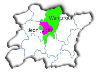
| 61, Jiam-ro, Yongjin-eup, Wanju_Gun, Jeollabuk-do |
Far East | Godang-ri, Unju-myeon |
East longitude 127 degrees 22minutes North latitude 36 degrees 02 minutes |
Jinan-gun, Jeollabuk-do |
820.94㎢ East-West 36km South-North 71km |
| Far West | Yimun-ri, Yiseo-myeon |
East longitude 126 degrees 59 minutes North latitude 35 degrees 49 minutes |
Gimje-si, Jeollabuk-do |
||
| Far South | Baekyeo-ri, Gui-myeon |
East longitude 127 degrees 06 minutes North latitude 35 degrees 37 |
Imsil-gun, Jeollabuk-do |
||
| Far North | Sinbuk-ri, Unju-myeon | East longitude 127 degrees 019 North latitude 35 degrees 37 |
Geumsan-gun, Chungcheongnam-do |
||
 |
|||||
| 군청 소재지 | 전라북도 완주군 용진읍 지암로 61번지 | ||||
|---|---|---|---|---|---|
| Far | Far East | Far West | Far South | Far North | |
| Summit of longitude and latitude | Name of Place | Godang-ri, Unju-myeon |
Yimun-ri, Yiseo-myeon |
Baekyeo-ri, Gui-myeon |
Sinbuk-ri, Unju-myeon |
| Longitude/Latitude | East longitude 127 degrees 22minutes North latitude 36 degrees 02 minutes |
East longitude 126 degrees 59 minutes North latitude 35 degrees 49 minutes |
East longitude 127 degrees 06 minutes North latitude 35 degrees 37 |
East longitude 127 degrees 019 North latitude 35 degrees 37 |
|
| Adjacent administrative District |
Jinan-gun, Jeollabuk-do |
Gimje-si, Jeollabuk-do |
Imsil-gun, Jeollabuk-do |
Geumsan-gun, Chungcheongnam-do |
|
| Total Area (㎢) | 820.94㎢ East-West 36km South-North 71km | ||||
| Location Condition |
It has the natural environment of Wanju-gun, including Daedun mountain Provincial Park,Songgwang Temple, and Wuyibong Waterfall Neighboring are a of landscape such as Moak mountain Provincial Park, Moak Mountain Tourist Complex,turtle Reservoir Easy access to back cities such as Honam Expressway and National |
|---|---|
| Topography | Wanju-gun connects with Jeollabuk-do Plain of Korea, and it forms large farmland around Mangyeong River and mountainous terrain of over 500m above sea level. The area around the special zone is located at 793m altitude above sea level The lowest altitude in the special zone is 103.69m, the highest altitude is 167.74m, and the average altitude is 125.13m with West-high, East low type. |
| Vegetation | The ecological naturalness in the special zone area is 1 grade, and the whole is composed of 2 grade and 3 grade. 30 More than 50% of trees are under 30 years old. Moak Mountain Provincial Park and its surrounding areas are designated as sanctuaries for wild animals and plants./ 1st natural view distribution region (North-West side) |
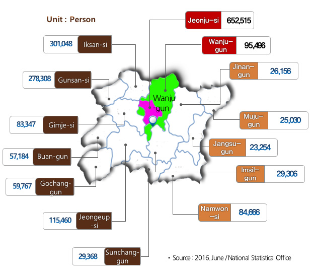
| Persons | Jeollabuk-do central city with a population of 748K (Jeonju + Wanju) |
|---|---|
| Area | 138,634㎡ |
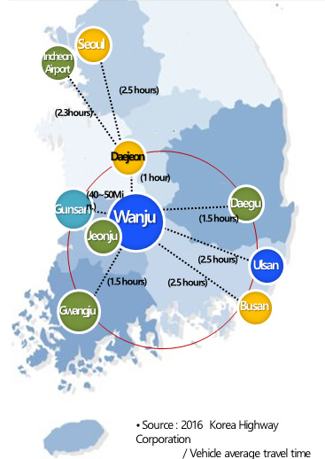
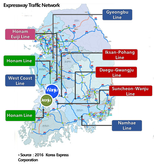
| Road Traffic | Honam Expressway / Route 27 Kwangyang• Nonsan Expressway / Goheung, Gunsan Line |
|---|---|
| Easy access to Major cities |
Within 1 to 2 hours of nearby major cities Seoul, Incheon, Daejeon, Daegu, Gwangju, Busan, Ulsan, etc. |
| Geographical Point |
Hub city of Jeollabuk-do area Located in 20 minutes from Jeonju Hanok village |
|
|
| Total population of Jeollabuk-do | 1,865,900 |
|---|---|
| Population of Adjacent Area |
748,011(40% Share) (Jeonju-si + Wanju-gun) |
| Population of Korea | 51,529,338 |
|
|
| Hanok Village in Jeon-ju |
• Located in Jeonju city, Jeollabuk-do province • 10 Million visitors per year • The population visiting the metropolitan area (34% of the total) • Annual sales : 115 Bil. won |
|---|---|
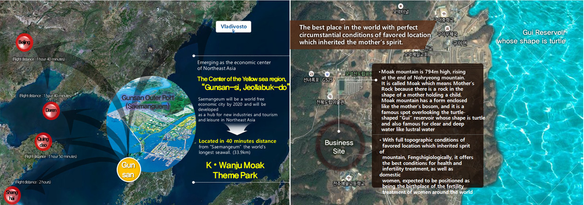
| K-Wanju Moak Theme Park | Located 20 minutes distance from Jeonju city |
|
|
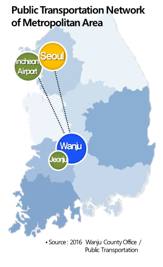
| Seoul / Incheon / Gyeonggi Traffic Access |
Kyeong-bu Line ▶ Honam Line ▶ Wanju : Approx. 192.4km West Coast Line ▶ Route ▶ Wanju : Approx. 199.4km |
|---|---|
| Daejeon / Gwangju Traffic Access |
Daejeon ▶ Honam/Euiji Line ▶ Wanju : Approx. 68.1km Gwangju ▶ Honam Line ▶ Wanju : Approx. 105.1km |
| Yeongnam Area Traffic Access |
Busan, Wulsan ▶ South Cost Line ▶SuncheonWanju Line Wanju : Approx. 144.3km Daegu ▶ Daegu-gwangju Line ▶ IksanPohang Line Wanju : Approx. 220.8km |
|
|
| When using Airport bus (limousine) |
Incheon Airport ▶ Jeonju ▶ Wanju : Approx. 4 hours 20 minutes Kimpo Airport ▶ Route ▶ Wanju : Approx. 3 hours 40 minutes |
|---|---|
| When using Express / Inter-city bus |
Central park, Kangnam ▶ Jeonju ▶ Wanju : Approx. 3 hours 10 minutes Seoul, South Bus Terminal ▶ Jeonju ▶ Wanju : Approx. 3 hours 15 minutes |
| When using railway (KTX / Saemaeulho) |
Yongsan(KTX) ▶ Jeonju : Approx. 1 hour 30 minutes Yongsan(Saemaeulho) ▶ Jeonju : Approx. 2 hours 10 minutes |